About this map
The project is associated with an interagency effort to develop a common framework of ecological regions (McMahon and others, 2001). Reaching that objective requires recognition of the differences in the conceptual approaches and mapping methodologies applied to develop the most common ecoregion-type frameworks, including those developed by the United States Forest Service (Bailey and others, 1994), the USEPA (Omernik 1987, 1995), and the NRCS (U.S. Department of Agriculture-Soil Conservation Service, 1981). As each of these frameworks is further refined, their differences are becoming less discernible. Regional collaborative projects such as this one in Texas, where some agreement has been reached among multiple resource management agencies, are a step toward attaining consensus and consistency in ecoregion frameworks for the entire nation.
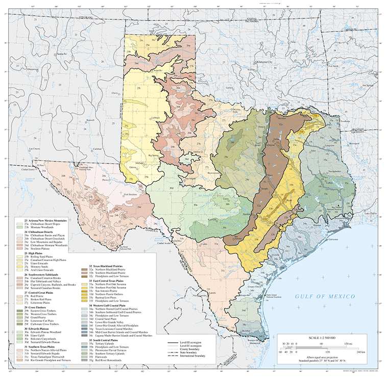
Level III & IV Ecoregions of Texas
The level III and IV ecoregions on this poster were compiled at a scale of 1:250,000 and depict revisions and subdivisions of earlier level III ecoregions that were originally compiled at a smaller scale (USEPA 2003; Omernik 1987). This poster is part of a collaborative project primarily between USEPA Region VI, USEPA National Health and Environmental Effects Research Laboratory (Corvallis, Oregon), Texas Commission on Environmental Quality (TCEQ), and the United States Department of Agriculture-Natural Resources Conservation Service (NRCS). Collaboration and consultation also occurred with the United States Department of the Interior-Geological Survey (USGS)-Earth Resources Observation Systems Data Center, and with other State of Texas agencies and universities.
Additional notes
The approach used to compile this map is based on the premise that ecological regions are hierarchical and can be identified through the analysis of the spatial patterns and the composition of biotic and abiotic phenomena that affect or reflect differences in ecosystem quality and integrity (Wiken 1986; Omernik 1987, 1995). These phenomena include geology, physiography, vegetation, climate, soils, land use, wildlife, and hydrology. The relative importance of each characteristic varies from one ecological region to another regardless of the hierarchical level. A Roman numeral hierarchical scheme has been adopted for different levels of ecological regions.
Level I is the coarsest level, dividing North America into 15 ecological regions. Level II divides the continent into 52 regions (Commission for Environmental Cooperation Working Group 1997). At level III, the continental United States contains 104 ecoregions and the conterminous United States has 84 ecoregions (United States Environmental Protection Agency [USEPA] 2003). Level IV, depicted here for the State of Texas, is a further refinement of level III ecoregions. Explanations of the methods used to define the USEPA’s ecoregions are given in Omernik (1995), Omernik and others (2000), and Gallant and others (1989).
This project was partially supported by funds from the U.S. Environmental Protection Agency Region VI, Regional Applied Research Effort (RARE) and Total Maximum Daily Load (TMDL) programs. (USGS, 2004)
Literature cited
Bailey, R.G., Avers, P.E., King, T., and McNab, W.H., eds., 1994, Ecoregions and subregions of the United States (map) (supplementary table of map unit descriptions compiled and edited by McNab, W.H., and Bailey, R.G.): Washington, D.C., U.S. Department of Agriculture-Forest Service, scale 1:7,500,000.
Bryce, S.A., Omernik, J.M., and Larsen, D.P., 1999, Ecoregions - a geographic framework to guide risk characterization and ecosystem management: Environmental Practice, v. 1, no. 3, p. 141-155.
Commission for Environmental Cooperation Working Group, 1997, Ecological regions of North America - toward a common perspective: Montreal, Quebec, Commission for Environmental Cooperation, 71 p.
Gallant, A.L., Whittier, T.R., Larsen, D.P., Omernik, J.M., and Hughes, R.M., 1989, Regionalization as a tool for managing environmental resources: Corvallis, Oregon, U.S. Environmental Protection Agency, EPA/600/3-89/060, 152 p.
McMahon, G., Gregonis, S.M., Waltman, S.W., Omernik, J.M., Thorson, T.D., Freeouf, J.A., Rorick, A.H., and Keys, J.E., 2001, Developing a spatial framework of common ecological regions for the conterminous United States: Environmental Management, v. 28, no. 3, p. 293-316.
Omernik, J.M., 1987, Ecoregions of the conterminous United States (map supplement): Annals of the Association of American Geographers, v. 77, no. 1, p. 118-125, scale 1:7,500,000.
Omernik, J.M., 1995, Ecoregions - a spatial framework for environmental management, in Davis, W.S., and Simon, T.P., eds., Biological assessment and criteria-tools for water resource planning and decision making: Boca Raton, Florida, Lewis Publishers, p. 49-62.
Omernik, J.M., Chapman, S.S., Lillie, R.A., and Dumke, R.T., 2000, Ecoregions of Wisconsin: Transactions of the Wisconsin Academy of Sciences, Arts and Letters, v. 88, no. 2000, p. 77-103.
U.S. Department of Agriculture-Soil Conservation Service, 1981, Land resource regions and major land resource areas of the United States: Agriculture Handbook 296, 156 p.
U.S. Environmental Protection Agency, 2003, Level III ecoregions of the continental United States (revision of Omernik, 1987): Corvallis, Oregon, U.S. Environmental Protection Agency-National Health and Environmental Effects Research Laboratory, Map M-1, various scales.
Wiken, E., 1986, Terrestrial ecozones of Canada: Ottawa, Environment Canada, Ecological Land Classification Series no. 19, 26 p.
PRINCIPAL AUTHORS: Glenn E. Griffith (Dynamac Corporation), Sandra A. Bryce (Dynamac Corporation), James M. Omernik (USGS), Jeffrey A. Comstock (Indus Corporation), Anne C. Rogers (TCEQ), Bill Harrison (TCEQ), Stephen L. Hatch (Texas A&M University), and David Bezanson (Natural Area Preservation Association).
Collaborators and Contributors
Philip A. Crocker (USEPA), Art Crowe (TCEQ), Micheal Golden (NRCS), Susan Casby-Horton (NRCS), James Greenwade (NRCS), Conrad Neitsch (NRCS), Shannen S. Chapman (Dynamac Corporation), Augie De La Cruz (TCEQ), Kevin Wagner (Texas State Soil and Water Conservation Board [TSSWCB]), Richard Egg (TSSWCB), Alan J. Woods (Oregon State University), Clark Hubbs (University of Texas), David L. Certain (The Nature Conservancy) and Thomas R. Loveland (USGS).
Reviewers
Charles T. Hallmark (Texas A&M University), Gordon Linam (Texas Parks and Wildlife Department [TPWD]), Milo Pyne (NatureServe), Judy Teague (NatureServe), and Raymond C. Telfair II (TPWD).